


Central American Odyssey
3rd to 23rd January, 2017
Trinidad to Guatemala aboard the MS Serenissima
Tuesday 3rd January, 2016 – Port of Spain, Trinidad
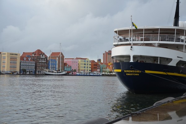
Arriving from our cold homesteads to the warm Caribbean breezes of Barbados there was a change that was more than just a change in weather, but a change of pace. Even in the hustle and bustle of getting our bags and navigating customs memories of bitter winds, sleet and cold began to fade quickly.Our mini-buses brought us to our home for the next 21 days – MS Serenissima, posed at the dock waiting to welcome us aboard. A refreshing glass of champagne washed away any traces of travel weariness and warm welcoming smiles and tasty snacks were gratefully received as everyone checked in to their nicely appointed cabins and began exploring the various spaces and corners around our sea-going home. We appreciated that we would only have to unpack once for the entire journey ahead, so all we had to do was eagerly anticipate the daily changes of scenery we would experience.Due to the late arrival of the flight, we enjoyed a nice buffet dinner in the Venice Restaurant. A long day of travel had come to an end so, after dinner, we retired to catch up on our rest and prepare for tomorrow’s adventure.
Wednesday, 4th January 2016 – Port of Spain, Trinidad
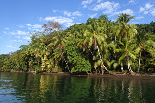
Here we are in Trinidad. The most southerly of the Caribbean Islands chain, Trinidad has wild Atlantic beaches as well as calm Caribbean shorelines and an incredibly rich array of flora and fauna. Despite the fact that skyscrapers abound in the modern city of Port of Spain, and we were docked alongside an industrial wharf, this exhilarating, cosmopolitan tropical island is also a land of natural beauty. And this is what we discovered this morning as we headed off to the Asa Wright Nature Centre to see some gorgeous hummingbirds. We boarded our mini buses and headed high into the rainforest hills of the Northern Range. The Asa Wright Nature Centre is spread out around a huge beautiful colonial house and has 2 square mile (5km2) pristine forest surround it. With the birdfeeders and fruit attracting all types of birds and there are supposed to be up to 159 species, I only saw about 30 species. For most, the hummingbird was the main attraction and we were given the rare opportunity to experience the magic of these tiny birds up close and personal.
As our guides led around the gardens we saw a vast amount of fascinating flora and fauna. We learnt that researchers form the New York Zoological Society had by studying this area closely for decades. Indeed we came to understand that it used to be a cocoa and coffee plantation before being transformed into a nature reserve. I really loved their mission statement: ‘To preserver a part of the Arima Valley in its natural state; to create a conservation and study area; and to protect the wildlife thereon for the enjoyment and benefit of all persons of this and succeeding generations.’ It was an amazing experience to see so many different bird species and of course some saw the rare bearded bellbird. The two hummingbirds I was extremely excited to see were the white-nape Jacobin and the tufted coquette, however most guests loved the colour and the photogenic nature of the purple honey-creeper, the contrasting colours of bright blue body with vibrant yellow legs was eye-catching. We were back on board the M/S Serenissima for lunch and in the late afternoon the mandatory safety drills drew us together for regulation formalities in the Andrea Lounge to be reassured of procedures in unlikely circumstances, this led to an ‘introduction to the ship’ and a chance to meet the expedition team. Following afternoon tea, Conrad gave an interesting presentation on neotropical birds. We all dressed up for this evening’s Captain’s Welcome Cocktails. Everyone ready for a celebratory drink to toast to such a festive occasion and an official welcome from the Captain and crew to you on board the MS Serenissima. A most successful & enjoyable day, continued on after dark with the formal Captain’s dinner in the Restaurant.
Thursday, 5th January 2017 – Isla Margarita, Venezuela
At anchor just off Isla Margarita, our first opportunity to go on the Zodiacs as they transferred us this morning only a short distance to El Guamache Port. Once ashore we had a special police escort around the island. Our guides on the bus told us all about Isla Margarita and Venezuela. How Americo Vespuccio named Venezuela ‘little Venice’ after seeing houses on stilts over a lake which reminded him of Venice. We learnt Christopher Columbus named Isla Margarita after the the princess of Austria. It was interesting to note that fishing (after oil) was the main industry on the island but only 5 years ago toursim was, indeed in 2007, 120 cruise ships came to El Guamache Port but in 2016 it was only 5 ships. So it was great that Noble Caledonia was leading the pack in coming back since the unrest. The first stop was the Pueblos de Margarita Museum, a beautiful respresentaion of colonial times. All of us enjoyed the opportunity to explore the little buildings and rooms. Some of us climbed the spiral staircase for breathtaking views of the coast and surrounding area. I particularly liked the statue in front of the church of Simon Bolivar. Famous (and on the $100 note) for bringing independence from the Spanish rule to the entire north-west of South America in the 1820’s. Venezuela’s biggest holiday island lies 40km to the north east of mainland Venezuela. It is composed of two islands linked by a crescent shaped sandbank – La Restinga. This is where we explored by local boat. We explored the labyrinth of mangrove lined channels all with cutesy names like Mi Dulce Amor (my sweet love) and Tunel de los Enamorados (Lover’s tunnel). Numerous pelicans and frigates were spotted flying overhead along with the various marine critters like jellyfish, crabs and seastars. One story our guide, Richardo, did mention which I found hilarious was the ‘las tetas de Maria’ - the boobies of Maria. Two hills we saw from our coach were called las tetas de Maria and the story goes they were name after a female Indian chief of the area. It was a local joke about the chief as she was flat chested. It was an afternoon at sea as we cruised to the Dutch Antilles. We still have much to do this afternoon. There would be some snorkel opportunities and thus those of us who wished to go snorkeling attended Lea’s informative lecture on snorkel safety, following this, guests where sized up and give the correct snorkel gear. In the late afternoon, following afternoon tea, Sir Michael Burton gave fascinating talk on Horatio Nelson and his life in the Caribbean.
Friday, 6th January – Bonaire, Dutch Antilles
We spent the morning sailing through the Caribbean Sea. We were kept busy with briefing from our Expedition Leader, Emma on our plans Curacao and Columbia. Lea then gave an exciting and educational talk on easy ways to identify the fish we will be seeing whilst snorkeling. At 12pm the MS Serenissima was docked alongside the wharf in Kralendijk, Bonaire. While Bonaire is often described as a jagged scrap of rocky land that broke away from South America long before the dinosaurs roamed the earth. And yes it is barren looking, it does have some amazing layers to it, both under and above the sea. This afternoon we had the opportunity to explore one of these aspects.
Some of us had opted to explore the diverse reef lined coast. Off we went on a specially made junk sailing boat – the Samur. Once we had boarded we set the first sail and slowly cruised to Klein Bonaire (Little Bonaire). Along the way our Captain introduced the crew and safety attributes of the little sailboat. He then spoke on the history of the ship (originally built in Thailand). We heard all about the Unesco World Heritage Bonaire National Marine Park and how Captain Don Stewart from the 1960’s to his death in 2014 worked tirelessly to protect the reefs of Bonaire and promoting eco-friendly diving. He ended up finding 84 spectacular dive sites around the islands of Bonaire. After dropping anchor of Klein Bonaire, we were transferred to the island by the little tenders. Two options for snorkelers, there was a drift snorkel for more advanced snorkelers which Expedition team members, Conrad and Gary organised at the south end of the beach. Team members Jane and Lea worked with novice snorkelers on the sandy beach near the boat landing. Lea gave an introduction to snorkeling class, and assisted the novice snorkelers with their equipment and although the water was a little choppy it was crystal clear and we were able to see a huge variety of fish. Whilst some of us explore the main island with a drive through the capital city – Kralendijk. Our guide spoke of the history and geography of Bonaire and how it was once inhabited by the Arawak Indians. Indeed the name Bonaire comes from the Arawak word ‘bojnaj’ meaning low country. Our drive around the island revealed desert landscape punctuated by surprising beauty. Klein Bonaire, where our intrepid snorkellers spent the afternoon, was clearly visible as we north from Kralendijk. As we drove along the coastline, we could see the limestone had eroded into all manner of shapes, including an arch where couples seal their marriage vows. Lat terraces on the limestone marked periods when the land was uplifted and at different heights, relative to today’s sea level. A quick photo stop was next and the flamingos showed their disinterest in our photography by keeping their heads in the water. At the Mangazina de Rei, in the Rincon area, we got a sense of the life that slaves endured during the brief respite from work on the salt flats on Saturdays and Sundays. And the liquor made from cactus that we had the opportunity to sample seemed to be an acquired taste; only a few took up the offer of seconds.
Continuing on to the south of the island, the salt mounds sparkled when the sun popped out from behind the thin cloud cover. Certainly the white slave huts made interesting composition for photos, allowing us to distance ourselves from basic condition that these huts represented. Both tours returned to the MS Serenissima in the late afternoon. At that time many of us discovered there was nothing hectic about Kralendijk and you really could not get lost in this cute little town. It was essentially made up of two main streets, the pretty sea front promenade and Kaya Grandi with its colourfully painted façades and coral mosaics of flamingos. It really was a large easy going village and had the feel and atmosphere of a tropical island. This thus was the perfect setting for a pre-dinner drink and watch the sunset over Klein Bonaire and the Caribbean Sea.
Saturday, 7th January 2017 – Curaçao, Dutch Antilles
We were docked in Willemstad’s Otrobunda (“The Other Side”). This is mainly a residential neighbourhood with some lovely examples of typical Curaçoan residences, old and new, in bright colours. During breakfast we witnessed a huge downpour outside, but only after a few minutes it had stopped completely! In the Caribbean they say, “If you don’t like the weather, wait 10 minutes…”. From our ship we had an excellent view of the old buildings waterside and scattered on the hillside that make St. George’s Harbour so charming. The brief rain shower had cleaned up the buildings and streets and made the harbour area even more picturesque. Despite the overcast skies and the threat of rain we headed off for our walking tour of Willemstad. It was like a small tropical Amsterdam with its enchanting mixture of Caribbean and attractive Dutch-style architecture. We were certainly impressed with the candy coloured, renovated colonial buildings which dated from the 16th to 19th century and lined the harbour. The ship was docked in Otraband (otherside) and we took a slow wander over the Queen Emma footbridge to Punda (point), crossing Sint Annabai Channel. It was a pleasure to walk around the mainly pedestrianised streets of Willemstad and our local guide pointed out some of the charming features of the city.
The Punda is where the waterfront pastel-coloured colonial merchant houses (Handelskade) are located. Crammed into this small area we saw shops restaurants, markets, monuments, a church, the oldest continuously used synagogue in the Western Hemisphere, the Governor’s Palace, and Fort Amsterdam, where our guide led through the maze of street and informing us of the history of the area. We ended the tour on the one side of the Punda near the famous Floating Market that consists of dozens of Venezuelan schooners with their owners selling fresh fish, meat, tropical fruits, vegetables and spices We were free mid-morning to wander at our own leisure around this historic harbour city, designated UNESCO World Heritage Site. The colourful Dutch architecture styles, “floating market” and teeming variety of shops made this a photographer’s and shoppers paradise! After an appetizing lunch most of us boarded large, modern, air-conditioned motor coaches for the Curaçao Country Drive tour. Outside of the city our bus stopped for a brief look the shallow salt ponds of Jan Kok where dozens of pink flamingos were gathered. As we traversed across the island we noted the contrast from its sister island, Bonaire. It was not as arid or as flat as Bonaire and we went through some forested areas that Bonaire also lacked. Colourful, brightly painted houses, from old plantation homes to new construction, dotted the landscape. From our local guides we heard that the houses were originally white, but in the 1800s the governor ordered that buildings be painted in colours. The popular tradition has continued and is iconic for the island’s buildings.
We discovered that some of Curaçao’s beaches are more secluded and beautiful that the ones we had seen previously. We stopped at one such beach that was a ways off the coast road. It was a gap in the ancient, craggy, up thrust coral reef with a beautiful white sand beach and sparkling clear azure water. Unfortunately, we only had time to admire it and not dive into its inviting waters. After reaching the west point of the island (appropriately named Westpunt), and seeing the beautiful beach there as we passed by, we proceeded along the northern shore for a stop at Boca Tabla National Park. The shoreline here was similar to the rugged, craggy coral rock northern shore of Aruba where incessantly crashing waves have sculptured the shoreline and sent up towering plumes of sea spray as we watched mesmerized by the sea’s awesome power. Venturing further south, away from the coast, we stopped at Kas di Pal’I Maishi (Old Labour House). Here we found a restored, thatched-roof slave cottage filled with antique furniture, farm implements, and clothing from centuries past. An expert local docent fascinated us by showing and demonstrating how slaves, and former slaves, lived and worked on the island. ]Later that afternoon MS Serenissima pulled away from the dock as we set sail for Santa Marta, Columbia. The last rays of day cast its warm glow on this delightful harbour as we sailed into the sunset.
Sunday, 8th January 2017 – At Sea
Today was a relaxing day at sea as we made our way to Columbia. White-capped waves topped the following swell and we gently rolled along under cloud-speckled skies and bright sun. From the bow observation deck our naturalist pointed out the birds curiously in flight around our ship, such as brown and masked boobies, and in flight around our ship were even fish! Flying fish (they actually glide, not fly.) launched themselves out of the sea at the sound our ship approaching and arched over the water until they splashed down some distance away. After a hearty breakfast Emma had scheduled a varied assortment of activities for us to enjoy. During our sea day, for those of us who signed up, we were treated to Engine Room visits to see the inner workings below decks and meet some of the crew responsible for our safe and comfortable passage. In the morning Guest Speaker, Sir Michael Burton introduced us to the real pirates of the Caribbean. And later in the morning expedition team member, Brian Seenan, presented his lecture, “A Simple Explanation of a Complex Geology”. After a tasty lunch we were at our leisure and quite a few of us joined expedition team member, Jane Thompson, for an informal water colour class. We were able to express our creative side with some fun artwork. After our recap and briefing we enjoyed a marvellous dinner paired with excellent wines.
Monday, 9th January 2017 – Santa Marta, Colombia
We awoke to strong winds that made our after breakfast docking at Santa Marta’s industrial ship dock especially challenging for our Captain regardless, he expertly guided MS Serenissima into her berth. For Colombians, Santa Marta is one of the most popular tourist towns offering liberal amounts of sun, rum and long stretches of sandy beaches. We had two options this morning, either a rainforest walk or a town walk. It was an 8am departure for those of us who opted for a rainforest walk. Our target for the morning was the Tayrona National Park, located about an hour’s drive away in the foothills of the Sierra Nevada Mountains, a range which rises over 18,700 feet. The National Park had been established between the mountains and the Caribbean Sea to preserve and study the rich biodiversity. We had an enjoyable hour’s walk along easy forest trails, stopping to experience the power of the Caribbean Sea at it crashes on Colombia’s shores after a fetch of hundreds of unobstructed miles. We climbed to a viewpoint, marked by an egg-shaped granite boulder spiritually important to the Tayrona Culture people, who still flourish even after several centuries of cultural disruption. Our hike through the coastal rain forest revealed magnificent glimpses of forest, mountains and coast, all at the same time. Although we could hear many birds singing, it was difficult to see them through all the green slime - though we did chalk up a striking redrumped tanager, a sleepy green heron - and some of us even saw a small troupe of rare (and usually shy) tamarins with punk rock hairstyles. We climbed back on our fleet of buses for a short drive to the Mirador Eco-Habs hotel for a delightfully fresh array of local fruit slices and soft drinks.
The Historic Santa Marta Tour departed on time at 9am and it was a short drive to the city centre. From there we mainly walked to the sites of the city. Along the way our guide spoke about the history of Santa Marta. It was in fact the first town created in Columbia by the conquistadors. Whilst there is not much colonial beauty it certainly has character and the welcoming and friendly locals. We noticed that there were plenty of well-preserved colonial buildings and some of the early churches still remain and had been restored. We had the opportunity to visit the Museum of gold (Museo de Oro), its original name was Casa de la Aduana, the customs house and was built in 1531. We headed up to the upstairs garret which was added in 1730 and offered us excellent views of the city and bay. Over time the customs house had many roles including a hospital, school, orphanage, care home and even a disco bar. It opened in 2014 as a museum and housed an interesting collection of Tayron objects, mainly pottery and gold as well as artefacts of the Kogi and Arhuaco Indians. I really loved learning about the Ciudad Perdida (lost city) and the model of the lost city was impressive. It has inspired me to commit to the 6 day hike into the jungle to see it – it is now on my “to do” list.
We continued on our walking tour to Colombia’s oldest church, however work on the cathedral was not completed until the end of the 18th century and thus it reflected the influences of various architectural styles. We meandered onto the leafy Plaza Bolivar with its statues of Bolivar and Santanda. The last stop on our walking tour of Santa Marta was another plaza which has had numerous name changes, initially called Plaza de Madrid, named after the man who established the local area, then re-named Plaza de San Antonio to acknowledge the military fortification. Renamed Plaza de Mercado, as it was a popular market place and when the market place moved to another square, it became Placita Veija de Mercardo (old market square) and lastly it was named de Plaza de los Novios (Plaza of the lovers), as in the 1960’s sweethearts would gather in the square and listen to the bands playing in the bandstand. Back on the bus, it was only a short drive to Quinto de San Pedro Alejandrino or the Grand Hacienda made famous as it was where the hero Simón Bolivar died in1830. The house has been engaged in cultivation and processing of sugarcane in the 17th century and had a mill and distillery on the property. The owner in the 1800’s was Joaquin de Mier, a devoted supporter of Columbia’s independence and invited Bolivar to stay in his home. Indeed as we wandered around the ground of the house we saw several monuments of Bolivar. We all met back on board MS Serenissima for lunch to prepare for our afternoon activities. Some of us relaxed on board, enjoying the spa and sunbeds on the foredeck, reading fascinating novels on the couches in the back deck or catching up on the zzzz’s. Quite a few of us though (those who had been on the Tayrona Tour) headed into town for a chance to see the city of Santa Marta.
Tuesday, 10th January 2017 – Cartagena, Colombia
This morning followed the route of Sir Francis Drake to the emerald city of Cartagena. From our ship we could not see any of the old city. Instead we saw modern, high-rise office buildings, apartments and beach hotels. Right after breakfast our morning tour began. Since the Rosario Island tour was cancelled due to strong winds, all of us took advantage of the opportunity to visit the city. We disembarked the ship on four large, modern motor coaches for the Best of Cartagena Tour. We started our exploration of Cartagena with a first stop at the impressive San Felipe Fortress, the largest work of Spanish military engineering in South America. It was not surprising that we weren’t the only ones there, approximately 6.5 million people visit Cartagena annually and, as we discovered, passengers of the two big cruise ships in port were visiting the splendours of Cartagena today. Taking a walking tour through Cartagena’s colonial walled city, along its cobblestone streets, with its attractive colourful buildings and beautiful squares (a UNESCO World Heritage Site) transported us back to the time of the Spanish Conquista. History came to life in the San Pedro Claver Church and Cloisters. Built in the 17th and 18th centuries in honour of San Pedro Claver, the patron saint of slaves, today it also houses the Afro-Caribbean Museum. Along our tour we visited the Inquisition Palace, which once served as headquarters to the Court of the Holy Inquisition, but today houses the Cartagena Historical Museum. Other interesting historical sites we visited included the Clock Tower, once built as the main entrance to the walled city, St. Domingo’s Cloister and the Cathedral of Santa Catalina. My favourite site was Botero’s famous statue ‘The reclining (fat) lady Gertrudis’ and the local superstition was that if you rubbed her breasts it would bring good luck. The fact that her breasts were quite discoloured compared to the rest of her suggested that the locals wanted a lot of good luck.
Our final stop was -- Las Bovedas Artisan Centre. Its 47 arches and 23 vaults were amongst the last constructions to Cartagena’s defensive system during the colonial times that were used as a jail and as a means of storage. Today, this edifice is home to handicraft stores where we shopped for souvenirs and emeralds. Out of time, most of us had to head back to the buses and return to the ship for a cool drink and a restorative lunch. Some of took up the opportunity to jump on the 3pm shuttle bus into Cartegena to explore it more fully at our own pace. A few of us headed to the port of Cartgena to see pink flamingos, colourful parrots and peacocks all within a few metres of us. It was fantastic to take close up photos of these usually timid animals.
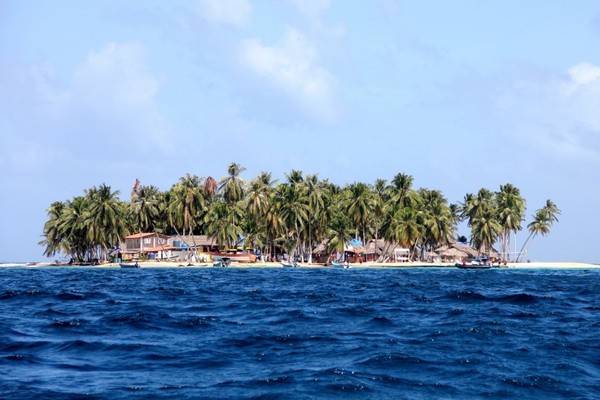
Wednesday, 11th January 2017 – San Blas Islands, Panama
Those who wanted to learn about the history of our next destination joined Sir Michael Burton for his presentation, “The Dramatic Construction of the Panama Canal”. This was an informative talk about the failures and successes that combined to create this engineering wonder of the World. Late in the morning we began to see islands scattered around us. We were in the Archipelago de San Blas and the islands we were seeing were the San Blas Islands (now named Comarca Kuna Yala). In this island chain there are 378 islands. Only a few islands are inhabited by the gentle native people called Kuna. Today we were given permission by the Kuna who own and control all of the San Blas to land on one of the islands – Aguja Island, a tiny low-lying island with a white sand beach and covered in coconut palms. After lunch we used the Zodiacs to transfer to Aguja for a day at the beach. (It looked like we could walk completely around this little island in less than five minutes). Reaching the island we had a nice dry landing on a short pier, and proceeded through an entry gate where we were greeted by some of the Kuna girls, dressed in traditional clothing. As we looked at our surroundings we noticed several small buildings that could be used as shelters for visitors and there were several visitors here in addition to our group. Scattered around the island and on the beach were people enjoying the sun, sand and sea. The Kuna had beach chairs for rent so many of us rented the chairs to provide ourselves with a comfortable spot to enjoy our visit. Just off the sandy beach we could see pelicans divebombing into the water trying to catch tiny fish from a large shoal just under the surface. Expedition Marine Biologist, Lea, pointed out the location for swimming unfortunately due to the strong winds and huge swells, snorkeling was cancelled this afternoon. Still most of us enjoyed frolicking in the warm waters of the Caribbean Sea.
In addition the wildlife viewing, we could enjoy here there was also shopping! The Kuna are known for their unique handicraft style called molas. These consist of sewing layers of fabric on top of each other and then cutting through various layers to create fascinating and colourful designs featuring animals, flowers or geometric patterns. The Kuna women had a potpourri of their beautiful molas on display for us to buy. After a day of fun and sun at the beach we returned to our ship in time for Afternoon Tea. Later, at Recap and Briefing, Andrea explained how our transit through the Panama Canal would work. She told us that Noble Caledonia had paid extra for a daytime transit to allow us to enjoy the views in daylight. He also told us that “daytime” means any time from sun up to sunset. For us the beginning of our transit through the canal could be at sunrise about 9:30am or could be 06:30am, the Expedition team would of course keep us in the loop. After a substantial and marvellous dinner we retired, eagerly anticipating tomorrow’s voyage through the Panama Canal.
Thursday, 12th January 2017 – Panama Canal, Panama
We enjoyed a leisurely breakfast and at 0900, Expedition Leader, Emma, announced the arrival of our ship’s Panama Canal pilot and the start of our transit through the Panama Canal. Even though we could watch our passage from the comfort of our cabins on our TVs, most of us went out on the forward Observation Deck to observe this first-hand since for most of us this was our first time through the canal. Also the cool morning air was quite pleasant as well. On board we had a Panama Canal pilot (required for all ships) who takes control of the ship from the captain and stays in control until the ship comes out of the canal on the other side. We also had a Panama Canal narrator on board with us and Pat would be with us for our complete transit. From the bridge Pat gave us commentary about the history, construction, and workings of the canal, in addition to an update about new expanded locks that had recently been completed for ships too large for the present locks. Even though the Panama Canal connects the Atlantic Ocean (Caribbean Sea) on the east to the Pacific Ocean on the west surprisingly the canal does not traverse east and west, but north and south! The Panama Canal consists of three locks, each with two identical locks side-by-side. One set on the north and two sets on the south. For over 100 years these locks have allowed ships to bypass the long and dangerous route from the Atlantic to Pacific Oceans around Cape Horn and shortening the distance by about 14,400 kilometres (9,000 miles). Today there are many ships too wide to pass through the Panama Canal locks so new wider locks are being constructed to handle those ships, while still using the existing locks to handle all other ships. As we approached the first set of locks (Gatun Locks) we found out that since we are a small ship we would be sharing the lock with a large cargo ship that slipped forward of us. We saw that to prevent any mishaps of ships bumping into the canal gates or each other each ship is tied onto four small electric locomotives, two on one side, front and back, and two on the other. These locomotives kept the ships’ line taut as they slowly moved along with us keeping us centred through the locks.
The Gatun locks, in two steps, would lift us from sea level on the Caribbean Sea (Atlantic Ocean) to a height of 26 meters (85 feet) above sea level to Gatun Lake, the largest artificial lake in the world and a key part of the Panama Canal system. Slowing progressing through the Gatun Locks we were amazed that something over 100 years old, built with early 20th century technology, was still operating without a problem today! Gatun Lake was created by flooding the rainforest. The little islands we see in the lake were once hilltops in the rainforest. Once inside Gatun Lake we anchored, among other ships, to await our transit time through the Gaillard Cut (Culebra Cut) and the western locks. One set of the southern locks was being serviced so the one set of locks was handling all the traffic, thus slowing down the movement through the canal. After lunch our transit time had arrived and we continued our passage. Now with the sun high in the sky the temperature and humidity has risen to stifling levels and most of us watch our progress from the air-conditioned comfort inside our ship. Also on-board, in our cabins, a Panama Canal documentary is playing continuously throughout the day so we can learn even more about this engineering marvel we are travelling through. The Gaillard Cut was the most challenging and costly excavating project of the whole canal. This is part of the Continental Divide of Panama. The builders of the canal were plagued by constant landslides that continued even after the canal was opened. As we approached the Gaillard Cut we could see the stair-stepped terraces that the builders had to dig into the sides of the ridge to prevent the landslides into the canal.
We passed through Gaillard Cut, without incident, and sailed under a beautiful modern bridge – Centennial Bridge. Our narrator told us that this bridge was built to be opened on the 100 year anniversary of the opening of the Panama Canal, 2014. Unfortunately, construction delays pushed back the official opening until this year, but it is named in honour of the Panama Canal 100th year of operation. By the time we reached the southern locks it was late in the afternoon. The delay at Gatun Lake has worked to our advantage! The scorching temperatures had diminished and a light breeze has arrived. We all gathered outside on the forward decks to observe our passage. When we finally exited the last lock and sailed out into the Pacific Ocean the sun was beginning to set. Our pilot and narrator took their leave and we anchored off Panama City.
Friday, 13th January 2017 – Panama City, Panama
When we woke this morning we were amazed by the Panama City skyline. From our anchorage we could see that Panama City has a beautiful skyline with modern, high-rise buildings along the sea. One of the largest and most impressive of the buildings (we learned later) was a hotel and casino built by Donald Trump. We disembarked via Zodiacs to Fuerte Amador Marina on Flamenco Island. The marina was filled with mostly large, enormously expensive, motor yachts. The marina matched the opulence of the yachts docked here with high-end shops and restaurants appropriate for the owners of these vessels. We then boarded our minibus for a tour of Panama City and as we drove along the 2km palm tree lined causeway which connects the island to the mainland, we had sweeping views of the city.
We had the opportunity to wander around Casco Viejo (Colonial Panama), declared a Unesco World Heritage Site in 2003. We learnt from our guide that following the destruction of the old city, the Spanish moved their city 8 kilometres southwest to a rocky peninsula on the foot of Cerro Ancon. The new location was easier to defend, as the reefs prevented ships from approaching the city except at high tide. It continued to exist as the main town but in 1904, when the construction of the Panama Canal began, the city boundaries moved further east and the cities elite abandoned Casco Viejo and the neighbourhood rapidly deteriorated. And today as we explored the narrow streets we noticed it was half crumbling and half high end. However the newly restored architecture gave us a sense of how magnificent the area must have looked in past years. We drove through the city and headed to the old city, founded in 1519 but burnt to the ground in 1671 by Captain Henry Morgan. Back to the main plaza where we met our minibus where we drove through the new city to see the old city We visited the Museo de Sitio Panama Viejo, where the highlights included an impressive scale model of Panama Viejo prior to 1671 as well as a few surviving colonial artefacts. We continued our exploration of the old city with a look at the ruins and the cathedral. Some of us then continued to Miraflores Locks for a chance to see it from the land and then this was the end of the tour. Most of us continued to see the new locks. We continued our tour by bus again, this time heading to the new panamax locks, Cocoli Locks and we enjoyed an appetising lunch at the locks. The expansion of the canal was considered to be one the biggest transportation projects in the world at a cost of around 5.3 billion US dollars and they are betting on the growing international shipping needs to cover the cost. The biggest challenge the Panama Canal faces is luring the enormous post-Panamax vessels, which currently depend on either the US Transcontinental Railroad or the Suez Canal. Only time will tell if they will succeed in making money. At the locks, we had the opportunity to watch a video of the building of the new locks, which gave us a great overview of just how much of construction took place. We then wandered down to the locks to the viewing station and saw a massive container ship transiting the locks. Back on the bus and our last stop was the Miraflores Locks Interpretation Centre. Here we were able to see the locks in action from the viewing deck, with ships heading in both directions, visit the interpretive and interactive displays, and view a video presentation on the construction and use of the canal and its locks. Again we met our minibus which returned us to Fuerte Amador Marina where our zodiacs were waiting Back on the ship before six pm, highly satisfied with our day’s experience, we enjoyed our Cocktail Hour before Neil’s briefing on the endeavour to travel deep in to the rainforest. Tonight we remained at anchor off Panama City in preparation for tomorrow’s excursion deep into the rainforest.
Saturday, 14th January 2017 – Chagres River, Panama
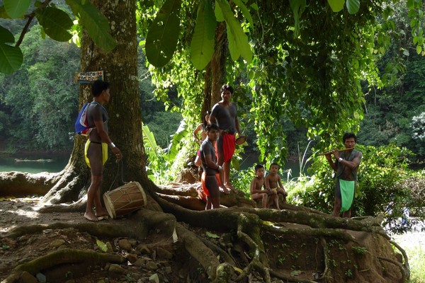
After an early breakfast, we disembarked by Zodiac again to Fuerte Amador Marina on Flamenco Island to board our buses and start our tour to meet the native peoples of the rainforest, the Embera. We had boarded the buses in an area that was formerly part of the U.S. administered Canal Zone. The buildings and grounds we were driving through were part of an enormous complex to build and, later, control and protect the Panama Canal. After a long bus ride we arrived at the landing on the Chagres River, in the Chagres National Park, where we would board our dugout canoes. The “landing” was just the road that ended in the Chagres River. Our drivers were Embera men covered with monochrome full body black tattoos and dressed in traditional loin cloths. Each dugout canoe was a single hollowed out log and about 6 meters (20 feet) long.
We cautiously boarded the canoes as they tipped slightly from one side to the other and carefully took a seat (a board, actually). Even though our drivers were wearing traditional clothing and driving traditional canoes they had modern outboard engines to power their craft up the Chagres River. We discovered that even though the canoes seemed very tippy and unstable the opposite was true. These were study craft well suited for the sometimes shallow courses of the river we were travelling up. As we sped along the river the rainforest seemed to envelope us then opened up to us with wide vistas, then enveloped us again. After about half an hour, around a bend in the narrowing river, we caught glimpses of some thatched huts peeking through the rainforest, above us, along the river’s edge…We had arrived! Our boatmen expertly landed our canoes on a spit of land jutting into the river’s bend. Coming down to meet us were the village women and children. The little boys dressed in loin cloths and the girls and women dressed in wrapped skirts and necklaces. Along the path up the river slope to the village were a group of men and young boys singing and playing their traditional musical instruments to welcome us. We all gathered in a long dirt-floored, thatched building that served as their meeting area. Just inside the building the village women had a table set up serving us soft drinks and water. We sat on long bench seats, created from halved logs, facing the centre of the structure. After we had all gathered, the village chief, through our interpreter, welcomed us and told us about his village and their lifestyle. After the chief’s welcome the village women served us lunch! They brought out large baskets made from woven palm fronds. Inside each basket were several smaller bowls made from cut and folded banana leaves. They handed each of us a banana bowl. Inside each bowl were a bit of filleted and fried Tilapia fish and three or four plantain patties. They were delicious! After our meals the women returned with trays of freshly cut pineapple. After our meal the chief gave us some free time to look around the village and meet some of his villagers...we could also shop! Around the inside perimeter of the meeting house were tables displaying handicrafts made by various families. Each table was from a different family. On display were wood carvings from what looked like mahogany, necklaces, and intricate, colourful, woven baskets. Outside the meeting house we explored the village. We found that the houses were constructed similarly. They were constructed on stilts with their floors about 2 meters (6 feet) off the ground. The roofs were thatched and the stairs up to the home were made from notches cut into a single log that was leaned up against the floor.
We were invited to enter the structure where the meals had been prepared. The villagers had constructed a regular staircase for our convenience and safety. Up inside the structure we found the strips of bamboo used for flooring were somewhat springy as we walked across them. At the far end of the floor was the kitchen area. There was quite a production line going. In the centre a woman with a large pot on an open fire was frying the same kind of fish that we had eaten earlier. Next to her a group of women were making the plantain patties and a couple of other women were putting the finished products into the banana bowls for serving. Surrounding the village square were additional individual huts constructed in the same manner as the other huts with raised floors and thatched roofs. A few huts had the brightly coloured material the women use for skirts draped along the sides of their huts. We found scraggly chickens running between the huts as we walked along. A steep trail led to the top of a small hill where the school was located. This was school was for the younger children. It was a simple concrete block structure with a metal roof, but it had a piece of 21st century technology just outside, a solar panel!
Back in the meeting hut they were playing music on drums and bamboo flutes as the villagers performed some of their traditional dances. After a fascinating and welcoming experience with the Embera it was time for us to take our leave. Back into the dug-out canoes and back down the Chagres River. Back on our motor coaches we could enjoy a nap on the way to the marina or watch the scenery as it changed from the jungle to the concrete and steel of Panama City. We were running a little late this afternoon, in actual fact two hours, and our bellies told us it was time for food. Once on board MS Serenissima we enjoyed a delicious dinner completely different in style, service and cuisine than our memorable lunch morning tea with the Embera. An afternoon of leisure and Expedition Naturalist, Conrad Weston, presented his talk, “Why Costa Rica is Costa Rica”. This was Conrad’s look at the history of his country from the first peoples to the present and the events that made Costa Rica the country it is today. It was an absolutely fascinating day.
Sunday, 15th January 2017 – Coiba Island, Panama
This morning we found ourselves among a number of islands between Panama and Costa Rica. This was going to be an expedition morning as we wanted to go snorkeling and swimming. A gorgeous sandy beach and crystal clear water awaited us at Granito de Oro. Coconut palms and sea grape trees lined and overhung the beach providing shade from the bright sun. The beach was terminated on each end by rocky ridges that extended into the sea and created a sheltered cove. The conditions were perfect for us and we explored the underwater world of this beautiful reef. As we enjoyed our buffet lunch, some of the Expedition Team went scouting to find a suitable landing site for our afternoon excursion to Isla Coiba (Coiba Island). The Team returned and reported that the tide was low and thus it was not good snorkeing at the moment but in an hour or two this would change. So swimming and relaxing on a beautiful, deserted beach and it also had a chairs, covered patio, even restroom facilities! Isla Coiba is the largest island in Central America, situated off the Panamanian province of Veragus. The island separated from continental Panama between 12- 18 thousand years ago when sea levels rose at the end of the last great glacial period. The island is thus home to many endemic subspecies including the Coiba Island Howler Monkey. Coiba was also home to the Coiba Cacaque Indians until 1562, when they were conquered by the Spanish and forced into slavery. In 1919, a penal colony was built on the island, becoming a feared place with a reputation for brutal conditions and extreme torture. The beach was several hundred meters long with bath-warm water lapping on the shore. Just behind line of coconut palms was a rainforest forming a dense, seemingly impenetrable wall of verdant jungle. A serene little beach with a few Ranger cabins at the back, and we mostly had the place to ourselves – not even a ghost of a prisoner to be seen. We arrived on the beach via a wet landing on the wide sandy beach. After swimming and frolicking in the water. Lars took a group of about 18 keen birdwatchers at 4pm to try to increase the bird list. Conrad also took a group for a wildlife and plant interpretive walk. Jane then led a group of 6 guests who wanted – and got – a bit of a leg stretch, climbing a steep path through the forest to a lookout point at 152 m above sea level. A strenuous hike but some of the roughest parts of the path had sets of wooden staircases and handrails. Still there was time for a snorkel and swim after these activities. A snorkel around the old pier revealed large schools for fish. Following a wonderful dinner many of us headed to the bar to chat about our fantastic experiences of the day at Granitio de Oro and Coilba Island.
Monday, 16th January 2017 - Gulfo Dulce, Costa Rica
Today we were in our sixth country of this tour – Costa Rica and we were sailing deep into the inner reaches of Gulfo Dulce, (Sweet Gulf) because we were entering Costa Rican waters for the first time we had to first stop at the port of Golfito and board local officials to clear customs and immigration. As we proceeded further into the Gulf we could see the rainforest covering the surrounding hills and reaching down to the water’s edge. Following an early breakfast we anchored and started our Zodiac excursion to shore. We did a wet landing on a beach just in front of a lovely little botanical garden named, Casa Orquideas (Orchid House). We were greeted on the beach by our local guides who would introduce us to the magnificent flora and fauna of the gardens. The owner and operator of this lush little hideaway was Ron, who with his wife, Trudy, immigrated here from the U.S. many years ago and created the gardens at their home as a source of income. The actual gardens comprise about 2.5 hectares and the rainforest land they own is about 20 hectares. Their property abuts a National Park so nothing will be built near them so it will always remain a wild, natural place. Remote and accessible only by boat these gardens feature tropical plants both indigenous and introduced to Costa Rica, and, as the name suggests – many species of magnificent, delicate orchids. We went off in small groups through the winding trails of the gardens, our guide identified and described the various species of plants here. We saw, and sometimes tasted many plants, including cacao (where chocolate comes from), papaya, pineapple, ginger, black pepper, nutmeg, vanilla, and chilli peppers. Rainforest trees towered over us festooned with various epiphytes. Colourful flowers in a rainbow of colours peeked out at us on every turn, especially an amazing variety of exquisite orchids.
In addition to the wonderful exotic tropical plants our guides also pointed out tropical animals in amongst the plants. The birds we spotted included toucans, macaws, green parrots, wood creepers, and more. We even saw a mammal sleeping inside a palm frond…a species of tropical bat with a face only a mother bat could love! Our guided tour of the gardens ended at a shelter where there was water, iced tea, pineapple, and watermelon for our refreshment. After our break we were free to roam the gardens on our own before we returned to the ship for lunch. Following cool drinks and a restorative lunch the afternoon was at our leisure. Some of us returned to the landing to further explore the gardens or enjoy a swim off the sandy beach.
Tuesday,17th January 2017 – Puerto Quepos, Costa Rica
We were all a little bleary eyed this morning, mostly due to having to get out of bed so early – breakfast at 5:30am! This cloudless morning we were anchored outside of the harbour at Puerto Quepos. The intense bright sun was already bearing down on us as we disembarked our Zodiacs for a dry landing at the dock. A comfortable 30-minute bus ride brought us to a small beach area where we exited our buses and we were split into small groups each with their own guide. Our guides then lead us on a short walk to the entrance of Manuel Antonio National Park. Manuel Antonio National Park was established in 1972 due to public protest against foreign landowners who planned a tourist development here that prohibited local access to the beach. It is named for one well known resident of the area. This is the jewel of the Costa Rica’s National Parks and is the most visited by both Costa Ricans and foreign visitors. Its boundaries preserve 1,983 hectares of fragile, tropical, coastal rainforest ecosystem with diverse flora and fauna. In addition to over one thousand different species of flora there is an abundance of wildlife including a variety of birds and monkeys. We arrived at the entrance to the park and easily passed through security after random bag checks. We made our way into the park with our local guides. The main trail through the park was wide, but our guides warned us to not wander from the trail because of the venomous snakes that live in the rainforest...no one wandered from the trail! The wide trail was bordered by the rainforest that provided some shade for us but regardless of the shade the heat and humidity were stifling. Just slowly walking along the relatively level trail caused us to get drenched in sweat. Our exertions were rewarded by the wildlife sightings our guides pointed out for us to see along our walk, including lizards, birds (Lesser Nighthawk, and Fiery-billed Aracari (toucan), bats, monkeys (White-Faced Capuchin) and sloths (Three-toed Sloth). After about an hour and a half our guides brought to Manuel Antonio Beach. Near the top of a large tree that hung over us a large Three-toed Sloth was lazing in the branches high above us. As we surveyed the beach in front of us we could see why locals had protested being denied access to this beach. This beautiful white sand, crescent-shaped beach was shaded by overhanging palms and sea grape trees and, on each end, rocky promontories jutted out into the sea. We were given a brief time to enjoy the beach. At the appointed time we gathered with our guides who led us along a narrow, boardwalk through rainforest. This was welcome because the boardwalk was completely enclosed by the rainforest and the shelter of the rainforest canopy prevented the sun from beating down on us. The buses were waiting for us at our drop-off location, but before we boarded our motor coaches our guides had set up tables under some shade trees where they were serving ice-cold water, tea with sliced watermelon and pineapple.
After our refreshment we were returned to the pier where Zodiacs were waiting to return us to our ship for lunch. After lunch we had the opportunity to visit the town, to enjoy the beach, do some sightseeing or sneak off for a delicious Gelato at the local marina. After a delightful dinner we migrated to the forward deck to continue our Costa Rica Night Special. There we were welcomed by a local Marimba band singing and playing conga drums, guitar and, of course, a marimba (xylophone), and traditionally dressed dancers. We indulged in specially concocted drinks from the Fo’s’c’le Bar as we were entertained by the music and the moves and flashing skirts of the swirling dancers. It seemed like the band was only getting warmed up when they had to play their last song and depart so we could set sail for our next Costa Rican destination.
Wednesday, 18th January 2017 – Puerto Caldera, Costa Rica
Around breakfast time our ship edged up to the dock at Puerto Caldera. Today we would be docked and departed our ship via the gangway. Another bright and sunny day greeted us as we boarded our modern, air-conditioned motor coaches for our respective excursions. Today we had to make a choice (Actually, we signed up a couple days ago) between one of two possible excursions. The first tour to leave was to the Monteverde (Green Mountain) Cloud Forest Biological Preserve. This was to take us to distant mountain peaks that appeared to be perpetually shrouded in clouds. We drove eastward off the peninsula, and joined the Pan-American Highway for a while, before branching off on a well paved road up a series of small volcanic mountain ranges clothed with forest and clearings where small farmers grow crops and raise Brahma cattle. Soon, though, the paving ended and was replaced by a dusty dirt road, which slowed our speed considerably.
Our guides told us the hotel and business owners in the Cloud Forest region prefer the lack of paving as the slower journey encourages more visitors to stay for at least two nights instead of just one. Where gaps in the vegetation permitted, we had wonderful views down over the fields and forests, the town of Puntarenas, and the Gulf of Nicoya. Our guides told us that a trade route runs up the gulf and the Tempisque River into the highlands, funnelling goods in both directions, probably for thousands of years. So after a 2 ½ hour drive we reached the entrance to the cloud forest we drove through the mountain top community of Monteverde. We discovered that this small community was a mecca for eco-tourism with many ecolodges, bed & breakfasts, inns, hotels, restaurants and outdoor adventure companies located here. Our main activity planned for today was a visit to the Monteverde Cloud Forest, a nature reserve developed in the nineteen fifties by Quaker immigrants opposed to the military draft in the United States, and because Costa Rica had just abolished its army at the same time. The Quakers saw the need for conservation of this unique environment and encouraged the Costa Rica government to create a large protected area. They also bought large tracts of their own land to protect it for posterity, and other tracts to farm and ranch on.
The reserve contains more than three thousand species of animals and plants. As we walked round a trail loop in the forest, our guides explained how the forest’s location high above the Pacific Ocean receives a steady supply of clouds, and the moisture they contain sustains and supports this ecosystem. We walked approximately three kilometres in almost as many hours, stopping frequently to observe wildlife. Among the species of birds spotted were solitaries, postman hummingbirds, which are said to gain their name from their habit of visiting more than 1.5 thousand flowers in the same order every day, trogons, honey creepers, tanagers, vireos and surely the prize of the day – a male and a female quetzal in glorious technicolour. The only nonbird seen was a small green anole, perched quietly on a leaf a metre or so off the trail, and we also saw quite a number of mushrooms and other fungi. The trees were festooned with epiphytes, vines and mosses, and even other trees such as the Strangler Fig. The Strangler Fig starts its life harmlessly from seed dropped in the host tree’s canopy by a bird or bat. Gathering moisture and nutrients from the air the fig sends roots down to the ground to gather more nutrients, then the strangling starts! The Strangler Fig’s roots start wrapping around the host tree like a giant botanical boa constrictor until the host tree is completely girdled by the fig. Within 60 to 70 years the host tree is “strangled” by the fig and dies with the fig extracting nutrients from the now dead and decaying host tree. In a few years the host tree has disappeared and the only evidence of the host tree’s existence is the empty tube of the encompassing roots from the Strangler Fig. Back at the trailhead, we took a few minutes to visit the Hummingbird Centre, located on a tree-covered rise just a few steps from the park entrance, where several different species were feeding, joined occasionally by a bananaquit. There were dozens of hummingbirds were flitting about among the hummingbird feeders and tree branches and tourists milling around. We delightedly snapped away with our cameras try to catch a winning photo of the birds on the fly, sitting on a branch or drinking from the hummingbird feeders. After the excellent tour, we re-boarded the buses and made our way partly down the mountain from our highest elevation of 1322 m, to the El Establo restaurant for lunch of rice and beans, beef and fish, salads, carrot soup, tea, coffee and juices. Our guides kept their eyes open on the way down and we spotted several troupes of howler monkeys high in trees above the road. For those of us going on the San José City Tour from Puerto Caldera our motor coaches headed east to San José, the capital of Costa Rica, where approximately one third of the country’s population of 5 million live. The city was founded in 1737 from the expansion of lucrative tobacco plantations in the fertile valley of Aserri and today is a lively blend of old and new. The first stop of the tour was in Sarchi where we used the restrooms, examined the oxcart painting and woodworking facility at this time we learned about Costa Rica’s famous ox-cart painting tradition. We then had some fresh fruit and did a spot of shopping before getting back on the bus for a quick photo stop at the giant oxcart which we heard was the world’s biggest ox cart. Then drove on to Gracia where we did a loop around the metal church Nuestra Senora de la Merced for photos.
We had lunch at the Swiss Travel's special event restaurant, Hacienda de Valle del Sol, a beautiful facility in the country suburb north of San Jose. Then on to San Jose where we disembarked at the National Theatre for a look inside the main entrance and our guide brought history to life as we climbed the marble staircases and gazed up at the famous fresco, a tribute to Costa Rica’s heritage as a coffee growing country, and marvelled at the grandeur of the foyer decorated in gold and Venetian plate mirrors. We walked down the block to the Gold Museum, an underground, modern and well equipped museum where we had a good hour to explore the exhibits and pick up a little something at the gift shop. Back in the bus for the several-block ride to the venerable, bullet-ridden National Museum which is opposite the splendid looking new Jade Museum. Again we had an hour to explore, including the butterfly exhibit at the entrance. All too soon it was time to re-board the bus and head back to Puerto Caldera and the ship.
Thursday, 19th January 2017 – Playas del Coco, Costa Rica
We anchored this morning just off Playas del Coco, a small tourist town, quite lovely and simple. We disembarked by Zodiac for a short ride in to a sandy beach, where we were met by our fleet of buses. Playas del Coco in Guanacaste Province is one of the oldest beach communities in the province and fastest growing tourism area in Costa Rica. It is affectionately known as El Coco by locals and Coco Beach by North Americans and Europeans. The town is located 22 km from the city of Liberia. Our coaches took us on an hour tour though rich agricultural fields of sugar cane, hay, corn, bananas, and cantelopes, which grow to maturity in 55 days or so under their protective irrigated plastic strip covers. Natural vegetation ranged from tropical dry forest along the coast to rainforest as we approached the Juanacasta Volcanic Range, extending up to and over the Continental Divide. Other agricultural fields contained cattle and goats. Our guide informed us that the modern sugar cane mechanical harvesters each replaced the hand labour of two hundred and fifty workers. Today, over two hundred thousand Nicaraguans still come to Costa Rica every year to help with the harvest. Sugar cane is grown for 5-7 years, then replaced for a year or two by other crops to help replenish the soil before reverting to cane.
We stopped on the Tempisque River where we boarded small tour boats for a fascinating nature excursion through the Palo Verde National Park. We were surrounded by tropical dry forest and cruising along the 4th largest river in Costa Rica. With the eagle eyes of our guides, we were able to spot quite a few crocodiles, lying in the shade or cruising at nostril depth in the river, iguanas, howler monkeys, white-faced capuchin monkeys, herons, egrets, sandpipers, kiskadees, social spiders and many more sightings in the trees, mangroves and the air, and on banks. As we left the river, we stopped beside a flooded field and watched a few dozen egrets, herons, ibises, stilts, whistling ducks, and a beautiful roseate spoonbill coming and going. The river and its adjacent marshes form an important ecosystem depended upon by many migratory birds travelling from North and South America. Our busy day then continued with a short bus ride to Haciendo El Viejo, where we visited a sugar cane processing plant. Our charming and enthusiastic local guide showed us how in the old days, oxen were used to turn the trapiche, a set of steel teeth through which cane was inserted by hand – resulting in frequent injuries. The cane juice was funnelled into a series of tubs, under which fires burned, using dried cane leaves, to boil the juice down into syrup. The adorable oxen was named Puntalito, meaning little snack, just 9 years of age and had to work just 3 minutes before being rewarded with a break and sugarcane to chew on.
Near the trapiche was a large bull ring, which we were told is no longer in use. We were then treated to a demonstration on the making of corn tortillas, at which some of us tried our hand, while the rest of us sampled the delicious product, along with cakes and juice and superb Costa Rican coffee to the strains of folk music endemic to this area. Our antics were closely watched by several gigantic iguanas, not in the least perturbed by our presence. A few howler monkeys also made their presence known from a nearby stand of trees. By now, after midday, we were ready for lunch and returned to the restaurant at Haciendo El Viejo and enjoyed a homemade lunch featuring Costa Rican dishes including the ubiquitous rice and beans. A relaxing drive home and once back at Playas del Coco in the late afternoon, most of us took the opportunity to wander around this quaint town for shopping and we some of us enjoyed a dip in the warm waters of Costa Rica before returning to the MS Serenissima. The absence of the sun’s burning rays enabled the outdoor temperature to drop to a more enjoyable level and allowed us to enjoy the special outdoor buffet Barbecue Dinner that had been prepared for us on the aft decks as part of a Costa Rica Night Special! Pura Vida ladies and gentleman…tonight we leave Costa Rica and make our way to Nicaragua.
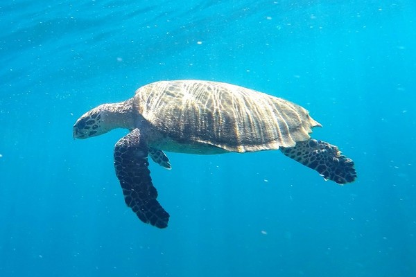
Friday, 20th January 2017 – San Juan Del Sur, Nicaragua
The port of San Juan del Sur is located on the Pacific coast of Nicaragua at the southern tip of the country. The fifteen thousand people of the small fishing town are outnumbered by a factor of three by the population of Ridley turtles that annually return to the nearly turtle refuge to lay their eggs. The port provides services to both passengers and cargo, as well as a fishing fleet, sheltered within a small natural bay backed by mountain ranges. The natural harbour was discovered by Spanish pilot Andres Nino in 1522 and was christened San Juan del Sur due to its location on the Pacific Ocean, known to the Spanish as Mar del Sur; another important port, San Juan del Norte, occupies the Atlantic coast. In 1846, Commodore Cornelius Vanderbilt connected the two ports, the San Juan River, and Lake Nicaragua, to provide a rapid and safe Transit Route for Gold Rush travellers. After breakfast, we disembarked by Zodiac for our tour of the historic city of Granada and a boat tour of a group of islets in Lake Nicaragua. Our bus tour took us through a landscape of agricultural fields, whose principal crops were sugarcane, bananas, cacao and coconuts. A geographically rich area with views of Volcán Mombacho and Volcán Masaya which is one of Nicaragua’s most visibly active craters.
Our first stop was Lake Nicaragua, where we boarded a flotilla of small canopied boats for a short crossing to a group of islets that were formed in the lake during an eruption of the Mombacho volcano around 20,000 years ago. The shallow waters are studded with isolated lava rocks, which kept our boatmen busy raising and lowering their outboards. This miniature archipelago has around 365 tiny tropical islands to explore. We spotted a variety of bird life, including ospreys, vultures, herons, egrets, woodpeckers, kingfishers cormorants and hummingbirds, as well as a few turtles basking on lily pads. Out boat driver showed us an absolutely divine flower – Paquira aquatica, and the packaging and unwrapping of this flower was just a delight. We met up with Walkiria, who is living on Isla de los Monos (Monkey Island), she was a captured spider monkey and kept as a pet. When her owners no longer wanted her, a local veterinarian brought her to the island to live as she had spent too much time in captivity. She has been on the island for two years now and they are looking for a mate for her. We continued our tour in the city of Granada, founded in 1524, and thus claiming the status of oldest European settlement in the Americas. This, and the efforts made to retain the colonial flavour of the city, contributed to its successful application to be declared a UNESCO World Heritage Site. Its picturesque location on the shores of Lake Nicaragua and in the shadow of the Mombacho volcano must have influenced the site selection by the founding fathers. Today, the city is a mosaic of colonial churches and government offices, narrow streets, and Spanish-style homes with beautiful indoor patios, tiled roofs, and colonial colours.
We visited the beautiful convent of San Francisco, which today houses a collection of pre-Columbian sculptures. It claims to be the oldest church in Central America and is the most striking building in Granada. I particularly liked the seeing the displays of the indigenous people, just the name ‘comelazatoaztegams’ sounded amazing and the fact it was a sort of 360 degree see-saw was fascinating. From here we headed for lunch at Hotel Dario. Fed and rested, we proceeded on to viewing La Merced church where we heard it was completed in 1539 but razed by pirates in 1655 and rebuilt with the baroque façade in 1783, damaged by William Walker’s forces in 1854 and restored again in 1862. Some free time for us was mostly spent in the shaded main plaza and a chance to photograph with elegant and picture perfect city. On our return to the ship, we freshened up and just before Dinner, Emma provided us with a briefing on our plans for tomorrow’s excursion to the historic city of Leon.
Saturday, 21st January 2017 – Corinto, Nicaragua
A city of awe-inspiring churches, fabulous art collections, stunning streetscapes and cosmopolitan eateries. This is what the colonial city of León offered us today. The MS Serenissima was tied securely to a dock there was only a light breeze as we boarded our motor coaches for our Colonial Leon, Art and History excursion. From the ship we rode through many agricultural fields. Many fields were growing sugar cane and peanuts, both big export crops for Nicaragua. After a ride of a little over an hour we arrived at the city of León. This city of 300,000 is the most important city in Nicaragua, after the capital city of Managua. Our guide told us that Leon was originally the capital of Nicaragua for over 200 years before Managua became the capital in 1851. The old city of Leon was destroyed by a tremendous earthquake in 1609. The city was rebuilt and, today, still retains its old architecture and streets from its colonial days.
First on our agenda was a visit to the birthplace and home of Ruben Dario. The old one-story colonial home was now a museum and showcased the life and achievements of this famous son of Guatemala. Just a short walk Ruben Dario’s house was the Ortiz Guardian Art Gallery. This is considered one of the best private art galleries in Latin America. This art gallery did not look very impressive from the outside, but once we got inside we were mesmerised by the many courtyards that it comprised. Each courtyard had a different architectural and horticultural style and sometimes displayed some unique work of art. Surrounding each courtyard were individual art galleries. I would say it is was one of finest contemporary art museums in all of Central America. The art on display was nicely counterbalanced by each courtyard since it encouraged a moment for pause and reflection.
We continued our walking tour and headed to the town square with its most treasured building, the Metropolitan Cathedral. This beautiful and imposing cathedral is the largest in Central America and the third largest in the Americas. Due to its size and prominence the Pope bestowed upon this cathedral the designation of basilica. This cathedral was one of our stops during our city tour. Officially known as Basilica de la Asunción, and is the cathedral’s fourth incarnation. The 1610 original was replaced in 1624 with wood-and-adobe structure which pirate William Dampier burned to the ground in 1685. Another adobe was built in its place before work on the baroque-style masterpiece began in 1747 and took 100 years to complete. Our guide gave us a tour inside the cathedral and pointed out Central American Odyssey, Voyage Log, 3rd to 23rd January, 2017 Page 28 various religious icons scattered throughout the building. He also showed us tomb of Ruben Dario, the father of Modern Spanish Literature, in an honoured location near the altar. We all had the opportunity to climb to the roof of the cathedral for great views of the city and volcanoes in the distance. The roof had recently been whitewashed so we had to remove our shoes to walk on the roof. As we walked across the roof we noticed its white domed spires were beautifully contrasted against the blue sky and puffy white clouds. I have often heard the phrase, ‘many people fall in love with Granada, but most of them leave their heart in León’ and today I would have to say that I totally agree. After our enthralling look at Leon we returned to our ship for a late lunch. Later that afternoon we had our last opportunity hear all about ‘Art and Belief in Central America’ a fascinating talk by Jane Thomson. In the wake of this it was time to dress up for the evening since it was the Farewell Gala Night starting with the Farewell Cocktail Party followed by the Captain’s Farewell Dinner.
Sunday, 22nd January 2017 – Acajutla, El Salvador
We were welcomed with open arms into El Salvador. This morning we were alongside the dock in Acajutla, Nicaragua. At the dock there were young men and women in traditional costume, dancing for us to lively Latin music. As soon as the gangway was placed most of us boarded mini buses for a full day tour – Mayan Route. A few of us boarded the mini bus for half day tour – Colonial Towns & Handicrafts. After an hour and a half ride our first stop took us back to the time of the ancient Mayan civilization.
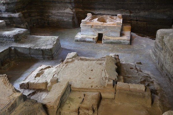
We visited Joya de Cerén,”the Pompeii of the Americas”. Around the 7th century A.D. an eruption of ash and steam, from Laguna Caldera Volcano, forced the Mayan residents to flee their village. In just a few days the village had completely disappeared under volcanic ash. It remained deeply buried for 1,400 years, until it was discovered by accident in 1976. Joya de Cerén is now a UNESCO World Heritage Site and is the only archaeological site that preserves an ancient Mayan commoner community. This community was a distance from the local Mayan ceremonial centre and shows how the average Mayan lived their daily lives. I was amazed to see a small dish showing finger prints smeared in the remains of an interrupted meal – a little surreal in fact.
We first visited the site museum, with our guides providing commentary, to see some of the artefacts unearthed from the site and learn about how their community was structured and how they led their lives. After gained a basic understanding of the community we visited the actual archaeological site to view some the community structures that had been uncovered as our guides explained the significance and use of each structure. Our next stop was at a nearby Mayan political and ceremonial centre, San Andrés, which was probably the centre for the villagers of Joya de Cerén. It is believed that up to 12,000 people lived here and the city once dominated the Valle de Zapotitán and possibly the neighbouring Valle de las Hamacas where San Salvador is now situated. After a visit to the site museum our guides led us to the partially excavated site that revealed the elevated temple mount (“The Acropolis”) which included the courtyard and royal chambers. After a busy morning of touring we were ready for lunch! Our lunch stop was at what our guides told us was the best restaurant in the city of Santa Ana, La Pampa. We sat inside of this stylish restaurant and were served our choice of grilled fish, grilled chicken or grilled marinated steak. The full meal with appetizer and dessert, and local Nicaraguan coffee, was delicious!
Now we headed a shop distance to the second most important city in El Salvador, Santa Ana. Here we stopped at the city centre for a guided tour of the ornate old Opera House, Teatro Nacional de Santa Ana, built 106 years ago, just after the turn of the century, with money from the coffee barons. This beautiful building is still in use for concerts and theatrical performances today. From the Opera House second floor we had splendid panoramic views of the city and it provided us a great photo opportunity for pictures of the grandiose Catedral de Santa Ana. Our guides told us that this imposing, white-washed Catholic cathedral is the only gothic architecture cathedral in Latin America. It was the combination of the cathedral and the theatre in town square which made this a beautiful experience. Certainly the traditional dancing added to the fun and ambience of this little plaza.
One final stop on our Mayan tour of El Salavdor – Tazumal. Located just outside of the town of Chalchuapa, this towering archaeological site is the most impressive Mesoamerican ruin in the country. Our guide walked us around the vast fourteen-stepped ceremonial pyramid, influenced by the style of Teotihucán in Mexico. Though with site possesses its own enigmatic beauty it is a small site compared to others in Central America. The site was occupied for more than 750 years and the Mayans abandoned the city around the end of the ninth century, during the collapse of the Classic Maya culture. We heard from our guide that then the Pipils moved in and occupied the site, building a pyramid dating back to 900-1200AD but abandoned it in 1200AD.
Those of us on the half day tour headed up to the volcanic mountains, along the Flower’s Route, named for the magnificent scenery with flowers growing along this winding mountain road. We stopped at the old colonial-style mountain town Concepción de Ataco. This quaint village has narrow cobblestone streets bordered by most old one-story buildings used for shops, restaurants and residences. We were given time to roach the village, and even do some shopping! We discovered that this village is an obvious tourist destination due to the nice restaurants and small inns and boutique hotels we saw here. We also discovered that it is not just the picturesque nature of the town that must draw visitors, it must also be the cool temperatures we found here too. It was finally the end of our day of touring so we boarded our buses, for the final time, for the trip down the mountain and our return to our ship. We watched the sun slowly descending in the sky as our buses wound their way down the mountain. When we were dropped off at our ship as the sun started to set. We had just gotten back on-board when it was time for our final dinner in the Venice Restaurant. As usual our chefs and wait staff served us a marvellous meal and gave us a pleasant memory of our dining experiences on-board M/S Serenissima. Before retiring for the night we returning to the Andrea Lounge for the World Premiere of the Central American Odyssey Slideshow, presented by Conrad Weston and the rest of Expedition Team. This was photo presentation of the photographic highlights of our trip. We not only enjoyed the show, we enjoyed even more the fact the team was giving this show to us on a flash drive that we could take home and show our friends.
Monday, 23rd January 2017 – Puerto Quetzal, Guatemala
Our final morning on board MS Serenissima and our 10th country in 21 days! As we said our “good-byes” we would, we hoped, sooner or later, come across each other in some exotic place, out on the water, once again to enjoy a journey of peoples, places & wildlife, learn & see some new things in this beautiful world of ours & certainly share a good laugh or two along the way.
End of Voyage
For further inspiration, view slideshow of images taken during the voyage